Image: Smoke from wildfires shrouded the San Francisco Bay Area and blocked sunlight on September 9, 2020. Credit: Aaron Maizlish/Flickr/CC BY 2.0
The year 2020 will be remembered for many things, not the least of which were a series of devastating fires around the globe that bear the fingerprints of climate change. From Australia and South America’s Amazon and Pantanal regions, to Siberia and the U.S. West, wildfires set new records and made news year-round.
It was an especially bad year for wildfires on the U.S. West Coast. Five of California’s 10 largest wildfires on record happened in 2020, and the state set a new record for acres burned. According to CAL FIRE, the state’s Department of Forestry and Fire Protection, more than 9,600 wildfires burned nearly 4.2 million acres through mid-December, causing more than 30 fatalities and damaging or destroying nearly 10,500 structures.
The Golden State wasn’t alone. Oregon, Washington, and Colorado were also particularly hard hit. In fact, as of mid-December 2020, the National Interagency Fire Center reported more than 10.6 million acres burned and nearly 17,800 buildings destroyed across its seven geographic area coordination centers in the western half of the contiguous United States.
It was the fire equivalent of a perfect storm. Record drought conditions across the Western United States in late 2019 extended into early 2020, and were followed by the hottest summer on record in the Northern Hemisphere. Add in unusually dry air, strong wind events, and an outbreak of summer thunderstorms in Northern California in August, and conditions were ripe for a dangerous fire season.
{vembed M=https://climate.nasa.gov/system/video_items/129_United_States_Map_of_Year-to-Date_through_8_September_2020_U.S._Drought_Monitor_Animation.m4v}Natasha Stavros is an applied science system engineer at NASA’s Jet Propulsion Laboratory in Southern California who studies wildfires. She says that not only is the U.S. West experiencing more frequent wildfires, but they’re also happening at the same time, putting a strain on resources. They’re also bigger, more severe, and faster than ever before, and more destructive, with 15 of the 20 most destructive wildfires in California history occurring within the past decade.
Stavros attributes these trends to three primary factors: a changing climate, greater availability of fuel, and the expansion of urban areas, which brings with it more ignitions.
Climate Change: A Powerful Catalyst
“Climate affects how long, how hot and how dry fire seasons are,” she said. “As climate warms, we’re seeing a long-term drying and warming of both air and vegetation.”

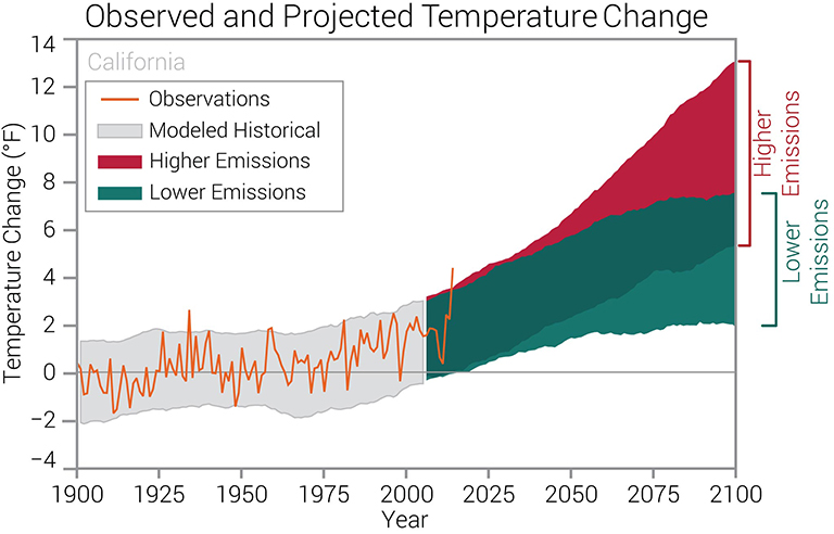
Observed temperatures are generally within the envelope of model simulations of the historical period (gray shading). Historically unprecedented warming is projected during the 21st century. Less warming is expected under a lower emissions future (the coldest years being about 2 degrees Fahrenheit warmer than the historical average; green shading) and more warming under a higher emissions future (the hottest years being about 9 degrees Fahrenheit warmer than the hottest year in the historical record; red shading). Credit: CICS-NC and NOAA NCEI
In recent decades, the U.S. West has warmed, and the frequency and severity of heat waves and droughts has increased. According to the National Oceanic and Atmospheric Administration (NOAA), temperatures in California have increased approximately 2 degrees Fahrenheit (1.1 degrees Celsius) since the beginning of the 20th century. This has dried out the air. Fire seasons are also starting earlier and ending later each year, while snow packs are shrinking, leading to earlier spring snowmelt and longer, more intense dry seasons.
These warmer and drier conditions are also making U.S. Western wildfires more severe. Another recent study led by Sean Parks of the U.S. Forest Service finds the amount of Western U.S. land burned by “high-severity” wildfires (fires that destroy more than 95 percent of trees) has increased 800 percent since 1985.
More Fuel to Burn
Another factor driving changes in U.S. Western wildfires is a greater availability of fuel. Drier air stresses vegetation, making forests more susceptible to severe wildfires, while droughts are creating more dead fuel. But, as Stavros explains, there are limits.
“Fire is both fuel- and flammability-limited,” she said. “Take the state of Washington. You have lots of trees, but it tends to be really wet and cold there, so fires are limited by the flammability of the fuels. In a place like Nevada, however, the amount of fuel is limited, but it tends to be dry. Droughts increase fires in flammability-limited areas, but don’t have an impact in fuel-limited areas. Ironically, you have to have rain to have a fire.”
Fuels in the Western U.S. are also building up due to a century of intentional wildfire suppression. “Prescribed fires are important to reduce fuels, while mitigating the effects of smoke,” she said. “For example, ozone, regulated by the Clean Air Act, is problematic in the summer season when conditions are optimal for ozone formation. Wildfire emissions can increase these concentrations. Altering the timing of smoke emissions through the use of prescribed burning so that emissions occur outside of the ozone season may have a positive effect and reduce health impacts.”
Ignition Sources on the Rise
Yet another factor driving changes in Western U.S. wildfires is a greater number of ignition sources, both natural and human-caused.

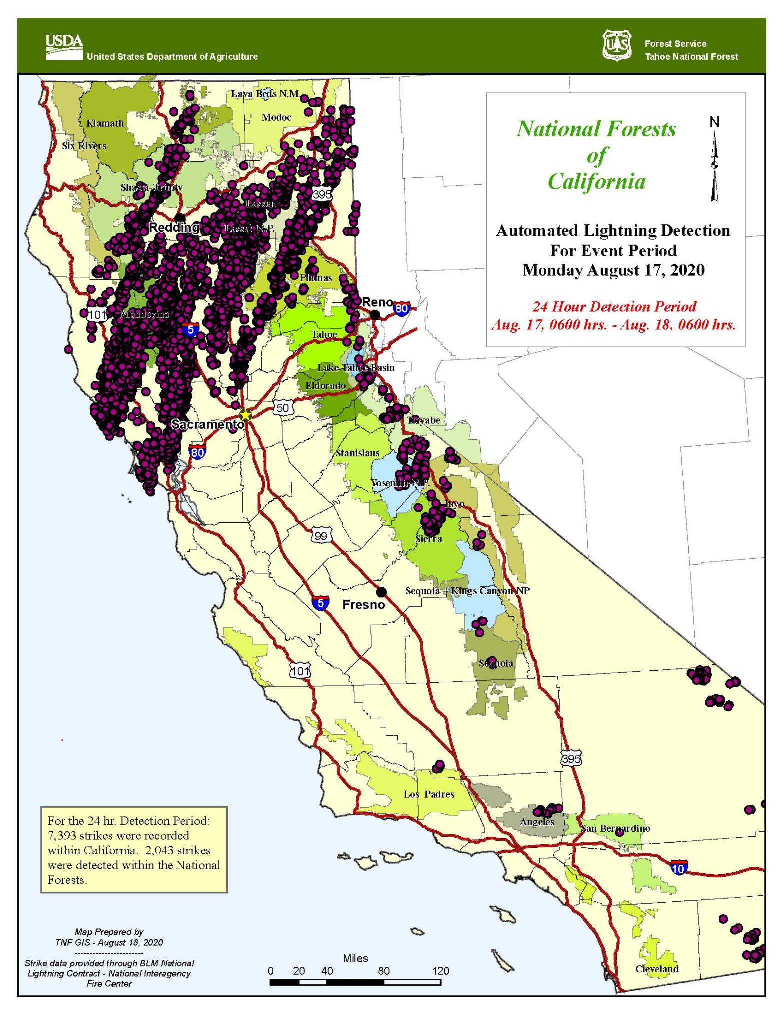
Wildfires caused by lightning tend to occur in remote areas that are harder for firefighters to reach. These lightning-triggered wildfires are occurring more frequently. According to the U.S Forest Service, between 1992 and 2015, 44 percent of Western U.S. wildfires were triggered by lightning. Those fires were responsible for 71 percent of all land burned. Some studies predict climate change will increase the frequency of lightning in the future, but further research is needed.
Human-caused fires are also on the rise, due to increased human development of land at what’s known as the wildland-urban interface – the edge of wildland areas. This significantly increases opportunities for both accidental and intentionally set wildfires. It also tends to make these fires more destructive to lives and property.
How Wildfires Are Impacting Climate
While the impact of climate change on wildfires is well-established, wildfires are also affecting climate, with associated impacts on ecosystems, air and water quality, and human health. These climate impacts may be significant.
Wildfires release carbon emissions that affect climate and drive climate change-related events that contribute to even more wildfires. The specific type of emissions they produce is determined by what they burn and how complete the combustion process is. The largest amounts of carbon emitted are in the form of carbon dioxide - a powerful greenhouse gas - and carbon monoxide. The quantity of each gas depends on whether a fire is flaming or smoldering. Dry fuels combust more easily and are more likely to be flaming.
To put the carbon dioxide emissions from wildfires into perspective, September 2020 data from the Global Fire Emissions Database show that California wildfires in 2020 generated more than 91 million metric tons of carbon dioxide. That’s roughly 30 million metric tons more carbon dioxide emissions than the state emits annually from power production.
Western U.S. Wildfires on September 10, 2020
In this side-by-side image, the left side image shows areas (marked in red) where wildfires were burning in the Western United States on September 10, 2020. Copious amounts of smoke spill off the coast and into the Pacific Ocean.
The right side, however, shows the real story of the danger that smoke poses. Using the OMPS (Ozone Mapping Profiler Suite) instrument, aerosols are detected and measured in terms of thickness and height of the atmospheric aerosol layer. For most atmospheric events involving aerosols, the AI ranges from 0.0 (colorless through light yellow, yellow, orange, and red) to 5.0 (deep red), with 5.0 indicating heavy concentrations of aerosols that could reduce visibilities or impact health. High aerosol concentrations not only can affect climate and reduce visibility, they also can impact breathing, reproduction, the cardiovascular system, and the central nervous system, according to the US EPA.
Since aerosols are able to remain suspended in the atmosphere and be carried in prevailing high-altitude wind streams, they can travel great distances away from their source and their effects can linger. The smoke released by any type of fire (forest, brush, crop, structure, tires, waste or wood burning) is a mixture of particles and chemicals produced by incomplete burning of carbon-containing materials. All smoke contains carbon monoxide, carbon dioxide and particulate matter (PM or soot).
Smoke can contain many different chemicals, including aldehydes, acid gases, sulfur dioxide, nitrogen oxides, polycyclic aromatic hydrocarbons (PAHs), benzene, toluene, styrene, metals and dioxins. The type and amount of particles and chemicals in smoke varies depending on what is burning, how much oxygen is available, and the burn temperature. Credit: NASA Worldview
Wildfires also emit aerosols (tiny, floating solid and/or liquid particles of organic and inorganic matter). These aerosols can come in the form of black carbon, brown carbon, or both. When a fire is really hot, it produces more black carbon, commonly known as soot, char, or ash. When fires are less hot and smoldering, they produce more brown carbon, which reflects light, making it appear brown or yellow. Both types of carbon warm Earth’s climate, but black carbon has a stronger warming effect. Scientists currently know more about black carbon and its effects on climate than they do about brown carbon.
Scientists are also working to better understand the amount of ammonia wildfires release. When mixed with sunlight, ammonia produces two secondary aerosols - ammonium sulfate and ammonium nitrate – both of which have a cooling effect on climate. Ammonia also contributes to the formation of brown carbon.
Recently, scientists studying the devastating Australia wildfires of late 2019-early 2020 discovered that an outbreak of a rare type of fire-generated thundercloud had punched into Earth’s stratosphere, the second lowest layer of Earth’s atmosphere. The large quantity of smoke that made it into the stratosphere then circled the globe, reducing the amount of sunlight that reached the ground for several months. The smoke slightly cooled Earth’s surface by an as-yet undetermined amount (likely a small fraction of a degree, similar to the cooling effect of a moderate volcanic eruption). The event illustrates how large future wildfires may, at times, have a slight cooling effect on climate.
Studying the trace gas and aerosol emissions from wildfires and prescribed burns was the objective of a joint 2019 NASA-NOAA field campaign called Fire Influence on Regional to Global Environments Experiment – Air Quality (FIREX-AQ). FIREX-AQ combined aircraft measurements, ground sampling and satellite data to correlate wildfire emissions to fuel and fire conditions on the ground; study wildfire plumes, including how they’re transported in the atmosphere and how they impact air quality downwind; and assess how effective satellites are in estimating fire emissions.
The air quality impacts of the 2020 U.S. Western wildfires were truly extraordinary, at times making day as dark as night and tinging skies in major urban areas a surreal red. Some locations recorded air quality readings higher than 500 on the Air Quality Index scale (anything above 300 is considered hazardous to health). But smoke doesn’t know state or national boundaries - it drifted east thousands of miles across many parts of the United States, north into Canada and even as far as Europe. Researchers at Stanford University in Stanford, California, estimated California wildfire smoke likely led to at least 1,200 and as many as 3,000 excess California deaths between Aug. 1 and Sept. 10, 2020 alone.
The series of images above shows the abundance and distribution of black carbon, a type of aerosol found in wildfire smoke, as it rode jet stream winds across the United States. The black carbon data comes from the GEOS forward processing (GEOS-FP) model, which assimilates information from satellite, aircraft, and ground-based observing systems. The Visible Infrared Imaging Radiometer Suite (VIIRS) on the NOAA-NASA Suomi NPP satellite acquired the images of the storms.
While satellite maps like this show smoke spanning the entire United States, that does not mean the smoke had equally strong effects on air quality at ground level everywhere. While people living in communities near the fires in California and Oregon faced very unhealthy and hazardous air quality between September 14-16, surface air quality in the eastern U.S. remained mostly good. That is because the smoke was traveling high in the atmosphere.
Credit: NASA Earth Observatory/Joshua Stevens, using GEOS-5 data from the Global Modeling and Assimilation Office at NASA GSFC and VIIRS data from NASA EOSDIS/LANCE and GIBS/Worldview and the Suomi National Polar-orbiting Partnership
Another climate impact of U.S. Western wildfires is their role in converting ecosystems from one type to another. Wildfires are necessary for healthy forest ecosystems. They help clear the forest floor of dead organic material, allow sunlight to reach it, add nutrients to the soil, provide habitat for animals and birds by clearing heavy brush so new plants can grow, and kill disease and insect infestations, among their many benefits. But when their frequency or severity is disturbed, it can throw things dangerously out of whack. In time, this may lead to the loss of some forests, as climate change increases the frequency of fires and makes it harder for ecosystems to reestablish.
“When you have major disturbance events like droughts and fires back-to-back in quick succession, you can change ecosystems,” Stavros said. “We’re starting to see this in some regions as wildfire frequency increases. Southern California’s mountains are covered with chaparral shrubs whose seedlings are only triggered to open by the extreme heat of a wildfire, and they’ve adapted to burning every seven to 15 years. If you increase the wildfire frequency, you begin depleting the seed bank and the chaparral may not regrow, because the only seedlings available for growth are often invasive species. In places like Arizona, Colorado, Washington, Oregon, and Idaho, we’re starting to see forests turn into prairies and grasslands. It’s not yet widespread, but it’s happening.”
Of course, the climate impacts of wildfires aren’t limited to the contiguous Western United States. In Alaska, increased wildfire activity is causing fires to burn through dense peatlands, releasing significant quantities of methane and carbon dioxide that exacerbate global warming. Other areas of global concern include Australia; Southeast Asia; the Amazon; Siberia, Canada and other parts of the Arctic; and even the Mediterranean region. The climate impacts of fires in each of these regions varies.
“The worst fires for climate are actually coming from Southeast Asia, the Amazon, and the Arctic, because you have carbon that’s been sitting there for a long time and then put back into the atmosphere when it burns,” Stavros said.
Adapting to a Fierier Future
One thing is clear: fires are likely to become an increasingly consequential fact of life as the U.S. West continues to get warmer and drier. Society will need to adapt.
“The impact of fire is much more than just area burned,” Stavros said. “It’s lives lost, infrastructure damaged, degraded air quality. We can use our scientific understanding to inform systematic approaches to managing how we live in a world with fire: how and where we build, how and where we perform maintenance on power lines, etc.
“Everybody cares when they can see and smell the smoke, but when it’s gone, they stop,” she added. “But the problem isn't going to go away.”
![]() Don't forget to feed the birds. Donate here
Don't forget to feed the birds. Donate here


